
Binghamton Neighbors and Block Records
The best public record for a Binghamton block is the parcel map. It shows parcel geometry and lets a researcher work outward from a single address. The related property record may show the owner of record, situs, mailing address, assessment information, and parcel ID. Deeds then confirm the legal transfer. Historical street-order directories can supply older occupants, while local organizations and archives provide neighborhood context rather than a current person-by-person roll.
Each source has a defined limit. A mapped parcel is not a survey or proof of occupation. A mailing address can be somewhere else. Historical books have publication gaps. The table keeps Binghamton neighbors research focused on the right record for the question.
| Source | What It Shows About a Block | Access |
|---|---|---|
| Broome Parcel Mapper | Parcel outlines, nearby lots, aerial layers and map tools | Free web viewer |
| Image Mate parcel search | Owner of record, mailing and situs addresses, parcel and assessment data | Free web search |
| County Clerk deed record | Recorded parties, legal description, date and instrument history | Guest search, document fees or counter access |
| Historical street directory | Past address-to-occupant or business entries where a volume exists | BCPL, NYSL, NARA and licensed collections |
| Community resource | Neighborhood projects, local history and public organization contacts | Public association or City resource page |
Owner records identify an interest in property, not every person at an address. The public voter lookup is an individual identity service and does not display a map of registered voters. A block can be researched without assembling a personal roster of Binghamton neighbors.
Find Binghamton Neighbor Parcels
The Broome GIS viewer accepts full or partial parcel ID, owner name, and address searches. Its help notes that partial terms such as a surname, a street number with name, or a parcel ID stem can work. Once a target parcel is found, zoom to block scale. A map click reaches the parcel detail, while adjacent polygon clicks reveal the surrounding parcel pattern. Measure and coordinate tools describe geometry; ownership details come from the linked parcel information.
The Parcel Mapper view captures the sort of selected parcel and nearby polygons used for a Binghamton neighbor check.
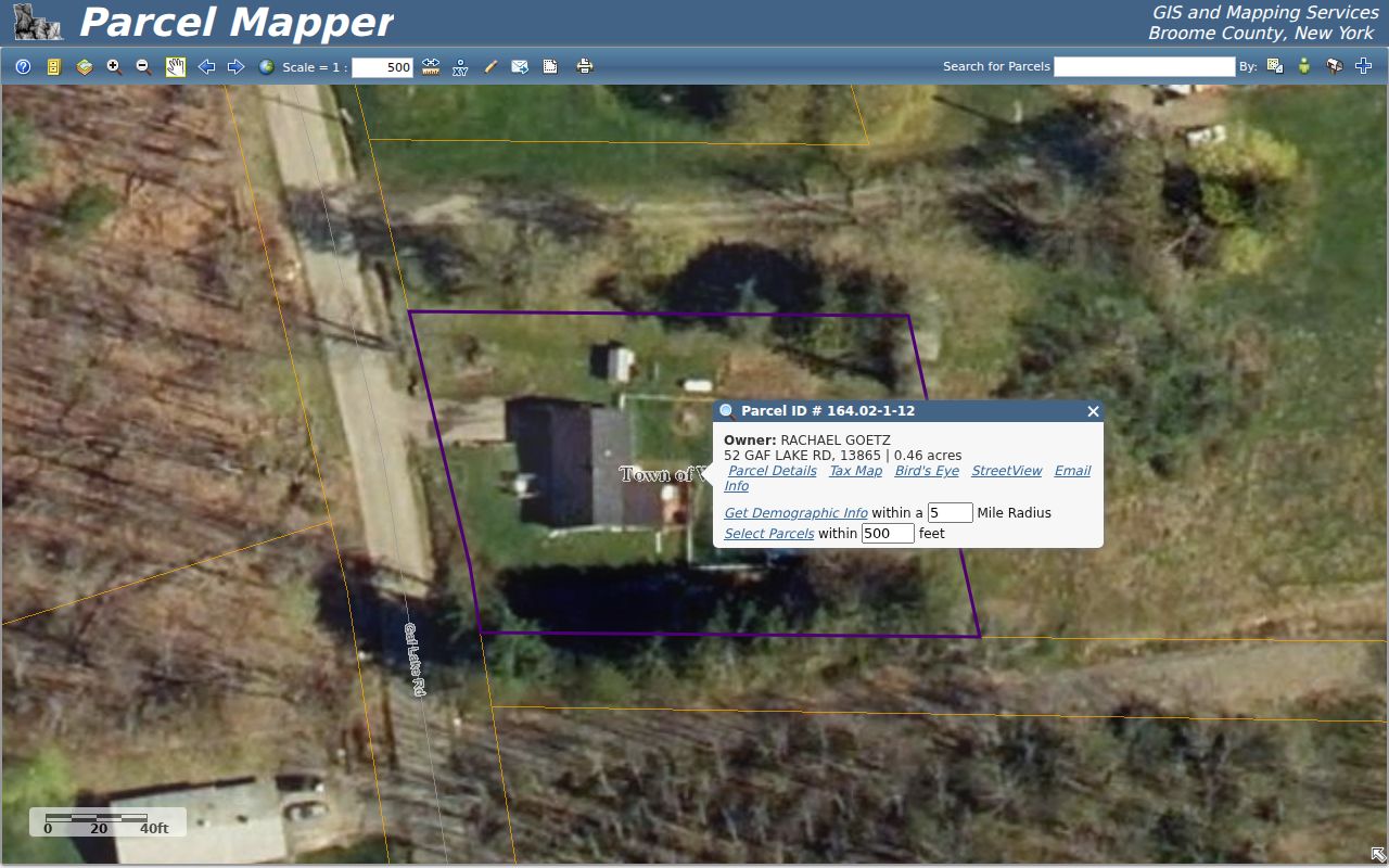
Use the image as a map-reading example, not a legal boundary. Broome warns that GIS material can be incomplete or out of date and is not a substitute for a survey or legal document.
Binghamton Neighbor Voter Rules
New York's public voter lookup asks for a county, first and last name, date of birth, and address details or ZIP. It is designed to confirm a registered voter's information, not to browse everyone on a block. A broader state or county voter-file request must state an elections purpose under Election Law §3-103(5). Confidential registrations under Election Law §5-508 stay outside public inspection and copying.
That restriction matters for Binghamton neighbors. A map and parcel record can describe nearby real property. They do not authorize construction of a block-level voter list. A no-match in the individual tool can result from a spelling or address issue, recent registration, inactive status, cancellation, or protected status.
Map a Binghamton Block by Parcel
A repeatable block method avoids confusing an owner mailing line with a person who lives nearby. Save each parcel ID as the map is read. Then use the public record that actually governs the next question. For a recorded ownership question, that means the Clerk index and document image. For an old block question, it means a dated directory or map rather than a current assessment card.
- Enter one street address in Parcel Mapper and record the selected parcel ID, situs, and municipality.
- Click neighboring polygons clockwise and make a short list of their parcel IDs, without inferring a household from the map.
- Open the matching Image Mate details to compare owner of record, mailing address, assessment facts, and legal parcel description.
- Use the Clerk's Party 1 search and deed image to confirm a property interest when a name matters.
- Switch to the Binghamton street directory for the fuller named-street record trail.
A parcel ID commonly has a dotted numeric form, such as 109.02-1-3.11. The county explains that the early digits help identify a tax-map sheet. Match that identifier and the legal description in a deed when an address or road segment is ambiguous.
Binghamton Community Context
Local organizations can explain a block's history, civic projects, and neighborhood boundaries, but the researched sources do not provide public household rosters. The West Side Neighborhood Association is especially useful for public property-research material, a council district map, zoning resources, and its House Stories chapters. City resource pages also identify neighborhood and business organizations. Use those sources for context and verified public contacts, not to infer private memberships.
| Organization or resource | Area or use | Public access |
|---|---|---|
| West Side Neighborhood Association | West Side history, property research, zoning and district context | Public site; no member roster located |
| First Ward Neighborhood Watch | First Ward community-watch references | Public program and contact references, no roster located |
| Southside Neighborhood Assembly | Southside community organization | Public organization listing, no member directory located |
| City Planning and neighborhood planning | Citywide maps, plans, zoning and historic preservation | Official department resources |
For historic club newsletters, photographs, or organization materials that are publicly held, use the BCPL Local History Center, Binghamton University Archives, and historical-society collections. Those channels give a Binghamton neighbor search an appropriate archival path.
Binghamton Aerials Show Change
Parcel Mapper offers aerial options reaching back to 1937 and later years including 1944, 1965, 1973, 1981, 1989, 1994, 1999, 2002, 2006, 2011-12, 2014, 2018, 2022, and 2025. These layers can help locate a changed footprint or compare a block before and after construction. They do not identify a person or prove when someone was present.
When an older Binghamton address does not line up cleanly, pair the map with cross streets, Sanborn sheets, tax-map lots, deeds, and the city historian. Research did not locate an authoritative citywide residential renumbering year, so a claimed conversion should be treated as unconfirmed until a custodian or historian supports it.
Check Binghamton Deeds Before Naming Owners
A parcel map is only the start of an ownership question. The Broome County Clerk maintains recorded deeds, mortgages, judgments, liens, maps, civil and criminal actions, and business or court documents with records described as dating to 1806. Its online history has separate practical dates: the Clerk page cites land records from 1935, Records Management cites 1946, and the deed FAQ says deeds from 1963 can be downloaded. Treat those as different search, index, and image milestones.
In the Clerk's guest workflow, Party 1 is entered LAST FIRST. If a book and page are known, the book needs the D prefix, such as D1234. The recording page opens before the deed image. Compare the parties, recording date, book or page, and legal description to the parcel. A deed can show a property interest, but it still should not be treated as a current occupancy list for Binghamton neighbors.
Online printing or download costs $1.90 by credit card under the deed FAQ, and in-person copies cost $.65 per page. For older documents or a chain that stops online, the Clerk counter and the originating department remain the appropriate fallback. The Clerk's free Fraud Alert also sends a notice when a subscribed name appears on a recorded deed or mortgage; the county cautions that same-name owners must be separated by checking the document.
Binghamton Postal Names Need a Map Check
Binghamton is both a city and a postal place name. The ZIPs 13901 through 13905 are grouped under Binghamton for postal use, but city lines do not follow every ZIP boundary. Nearby Town of Binghamton, Chenango, Dickinson, Union, and Vestal parcels can carry the same postal city. The 13902 ZIP is identified as PO-box-only in the USPS OIG Binghamton sorting-center report. A mailing line alone cannot assign a property to the City of Binghamton.
Read the parcel municipality or SWIS information with the situs and map layer before deciding which assessor, code office, or court might have a record. USPS address lookup verifies delivery ZIPs, while county GIS establishes the parcel's local government context. This distinction prevents a Binghamton neighbor search from mixing records from different municipalities that share a postal label.
Compare Binghamton Neighbor Sources
Official and commercial tools answer different kinds of questions. The first group points back to a government or archival custodian and identifies a defined record. The second category can combine brokered, public, and user-provided data with an uncertain update schedule. Neither category turns an address into a complete list of Binghamton neighbors.
| Official or archival records | Commercial lookup category |
|---|---|
| Links a parcel, deed, map, or historical volume to its source office or collection. | May combine entries from varied sources and may require a subscription. |
| Lets the reader inspect record dates, fields, and access limits. | Can contain stale or misattributed entries and needs separate verification. |
| Supports a defined property or history question. | Does not replace a parcel detail, deed image, or custodian record. |
Binghamton Neighbor Privacy Limits
Household membership, private utility accounts, delivery data, DMV addresses, confidential voter records, and ACP-protected locations are not ordinary public block data. New York's Address Confidentiality Program supplies qualifying participants a substitute mailing address, and the actual address remains confidential except in limited legal circumstances. FOIL does not erase those protections. A property record can be informative without answering who occupies a home.
Lawful use. Use Binghamton neighbor information for lawful personal, family-history, property, civic, or safety research. Do not use records to watch, stalk, harass, intimidate, or harm a person.